At last, Africa in its full-sized glory
164 members of the United Nations backed the African Union’s ‘Correct the map’ campaign (presented by Togo) to shift away from the 16th Century Mercator map of the world which has erroneously depicted Africa as much smaller than it actually is while making countries closer to the poles appear much larger than they really are. […] The post At last, Africa in its full-sized glory appeared first on New African Magazine.
 Black News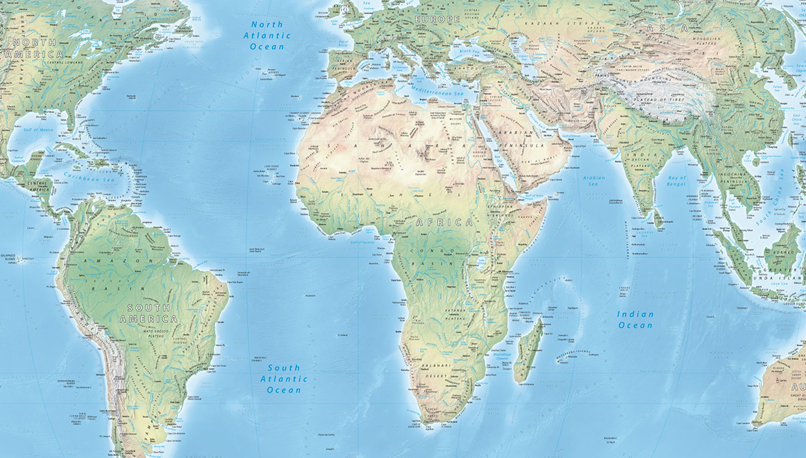

164 members of the United Nations backed the African Union’s ‘Correct the map’ campaign (presented by Togo) to shift away from the 16th Century Mercator map of the world which has erroneously depicted Africa as much smaller than it actually is while making countries closer to the poles appear much larger than they really are.
Europe, Canada, Russia and, above all, Greenland appear on the so-called ‘Mercator’ maps as being much larger than they actually are while Africa, with an area of 30.37m km², appears to be barely as large as Greenland, which covers only 2.2m km² – an area approximately fourteen times smaller?
The answer for this distortion goes back a Flemish cartographer named Gerardus Mercator (1512–1594), who in 1569 created a projection intended primarily to facilitate maritime navigation. The method used for the projection of a three dimension world in two dimensions had the effect of making regions near the equator appear much smaller than higher latitude areas which appear much larger than they are.
This distortion was skilfully exploited for political ends to justify Europe’s mercantilist ambitions and territorial conquests.
Widely used in Western atlases and education systems, this representation served to reinforce, or even justify, a worldview that favoured the countries of the North.
Whilst this may not have been Mercator’s original intention, it must be assumed that it must have suited some parts of the world, given that it is not until 2026 that an overwhelming majority of countries decided – without any binding effect – to put an end to it. Yet Mercator’s projection of 1569 was designed for European navigation, well before the complete colonial conquest of Africa.
Following the vote at its headquarters in New York, the UN general assembly officially retired the 16th-century Mercator projection in favour of one based on the more accurate 2018 Equal Earth design. (See below).
While this UN resolutions is non-enforceable, it is expected that there will be a near universal updates in educational, administrative and official projections.
Following the Berlin Conference (1884–1885), at which the European powers divided up Africa without African participation, the Mercator map became the dominant representation in colonial atlases, government departments, the mercantilists of the time, and the system of knowledge transmission—schools, and so on.
The stark visual magnification of Europe, Canada and Greenland, compared with equatorial regions, helped to normalise a hierarchical view of the world.
Several postcolonial scholars argue that the map is not the cause of colonialism, but that it served as a symbolic vehicle for a Eurocentric worldview. Yet in the Eurocentric accounts of James M. Blaut it can be demonstrated that European wealth after 1492 was largely due to the colonial exploitation of the Americas, Africa and Asia.
The war of the maps
This had a major influence on geographical representations of the world. As early as 1973, the German historian Arno Peters (1916–2002) popularised an equal-area projection (Gall-Peters) and argued that the dominance of the Mercator projection contributed to a worldview favouring the industrialised North.
He argued that Africa, Latin America and South Asia appear visually smaller than they actually are. This led to the ‘Map Wars’ in the 1970s and 1980s, involving not only geographical experts but also teachers, clergy, politicians and civil society organisations working in the field of development.
Having been criticised on several occasions for their role in facilitating colonisation and the exploitation of other peoples and their resources, the clergy, through the World Council of Churches, opted in 1980 to promote the ‘Peters projection’ in their development education programmes, arguing that an accurate representation of areas facilitates a better understanding of global inequalities and the realities of the Global South.
United Nations organisations such as UNESCO and UNICEF have promoted the Peters projection in education and in the management of their projects in order to accurately represent the reality of countries in the Global South and to encourage a less Eurocentric view of the world. Equality in the estimation of land areas has implications for programmes relating to demography, health, development and the allocation of financial resources.
The question remains: how did the unilateral policy of conquest and denial of other cultures lead to the flattening of the world and the imposition of a European standard regarded as universal and global?
Flattening the earth implicitly means simplifying and standardising the world according to the law of the strongest. As we know, this way of thinking has not disappeared.
The distortion corrected
On 4 September 2026, during its 80th session, the UN General Assembly adopted the resolution ‘Correct the Map’ tabled by Togo and the African Union, with France among the co-sponsors.
The text, passed by 164 votes to one (the United States) with six abstentions, encourages the phasing out of the Mercator projection in favour of the Equal Earth projection, which accurately reflects the actual areas of the continents.
The non-binding resolution calls on states, schools, international organisations and technology companies to prioritise equivalent maps when relative size is important.
The White House has strongly denounced it as a “radical ideological project”, whilst on behalf of the African Union, including Togo, Robert Dussey, the Minister for Foreign Affairs, Regional Integration and Togolese Abroad, presented the initiative as an act of “cognitive justice and reparation of memory”.
The six countries that abstained were: Estonia, Georgia, Lithuania, Moldova, Serbia and Ukraine, presumably due to a desire to maintain close relations or to avoid possible retaliatory measures by the United States.
The United States has raised a number of objections. In particular, it denounced an initiative deemed ideological with the resolution as a whole described as a ‘radical ideological project’ rather than a technical measure relating to cartography.
It said it was a distraction for the General Assembly from the UN’s priorities, which should focus on the ‘real issues’ of peace, prosperity and international relations, rather than cartographic projections.
It thoroughly criticises issues relating to historical reparations – in particular the concepts of ‘cognitive justice’ and ‘memorial reparation’ – as an unnecessary politicisation of the cartographic issue and, finally that the initiative serves to divert the UN from its fundamental mission and which would undermine its credibility.
The line of argument that won the support of the vast majority of countries can be summarised in two statements by Minister Dussey: “A fair world begins with a fair map” and “Maps shape our understanding of the world. They guide education, fuel the imagination and influence collective perceptions”.
Symbolic minimisation of Africa
The UN resolution echoed the main argument put forward by the African proponents: the abnormal distortions of the Mercator world map have contributed to a ‘symbolic minimisation’ of Africa and African peoples.
This resolution entitled ‘Correcting the map ’: Rebalancing Global Cartographic Representation and Promoting an Equitable Representation of the World’s Regions, in Particular Africa” makes an observation that can no longer be denied.
The UN de facto and officially recognises that ‘certain cartographic distortions of the sizes of the continents, inherited from history, have contributed to erroneous perceptions, leading in particular to a symbolic minimisation of Africa in the collective imagination and systems of knowledge’.
The correction of these distortions is described as an ‘act of cognitive justice and memorial reparation, and highlights the fact that “distortion contributes to minimising the perceived sizes of Africa, Latin America and South Asia, and perpetuates an unbalanced view of the world”.
Resolutions of the United Nations General Assembly are not legally binding. They constitute recommendations addressed to Member States or to the Security Council.
Article 10 of the United Nations Charter provides that the General Assembly may ‘make recommendations’ to Member States or to the Security Council. However, as the United States, like other permanent members, holds a veto, a negative vote in the General Assembly has no chance of being overturned in the Security Council and ever becoming a binding decision – especially under the leadership of the man (Trump) who has not apologised for referring to Africa as a continent of ‘shit’.
How big is Africa?
With a surface area of approximately 30.37m km², Africa could simultaneously accommodate the United States (9.83m km²), China (9.60m km²) and India (3.29m km²), totalling nearly 22.72 m km².
This would leave around 7.65m km² available. This remaining space would still be sufficient to accommodate a large group of European countries, including Ukraine, France, Spain, Sweden, Norway, Germany, Finland, Poland, Italy, the United Kingdom, Romania, Greece, Bulgaria and Iceland, whose combined area totals approximately 4.63m km².
Africa could accommodate three major powers and 14 medium-sized powers. There would still be nearly 3m km² remaining, sufficient to accommodate several states from Latin America and the Caribbean, such as Argentina (2.78m km²), Uruguay (176,000 km²), Jamaica (11,000 km²), Trinidad and Tobago (5,100 km²), Barbados (430 km²) and Saint Lucia (620 km²).
In other words, Africa is more than three times larger than either the United States or China taken individually, nearly four times larger than Australia (7.69m km²), more than nine times larger than India and nearly eleven times larger than Argentina (2.78m km²). and so on.
The end of the Mercator projection’s hegemony over world cartography is a sign that ‘weakly powerful countries’ are asserting their sovereignty. The controversy surrounding the cartographic representation of the world serves as a reminder that maps are also instruments of power.
Furthermore, just as disinformation kills, distorted cartography maims and humiliates peoples and serves to justify the unjustifiable.
The post At last, Africa in its full-sized glory appeared first on New African Magazine.